Moving around the Sunbury Central Precinct
Background
In 2024 Hume City Council adopted the Transport Strategy 2024-2034 following community feedback. The Strategy's Vision is:
The next step in making the Transport Strategy come to life is to prepare a transport plan for each of Hume’s thirteen precincts. We are starting with the Sunbury Central Precinct and looked at how residents move day to day, at a local level.
The transport plan prioritised small, quick, high impact fixes that can meaningfully improve your life soon. The focus is on identifying projects where Council controls the infrastructure.
The transport plan guides future investment and identifies priority projects.
Council looked at a wide variety of datasets including demographic, traffic, and trip origin and destination information. This helped us see how day to day travel is working.
What are we asking?
Prioritise projects
Council has identified 11 projects which will either:
- link major footpaths
- or provide safer road crossing.
This will make getting around easier and safer for people walking, scootering and for those using mobility aids. We need your help in choosing which ones to seek funding for first. Go to the 'prioritise projects' and choose the three you would like to see rolled out over the next few years.
Delivering the priority projects will take time and can’t happen all at once. Seeking community feedback helps to identify the priorities and inform future Council investment and grant funding applications.
Verify mapped information
Using various sources of data we mapped the walking environment and the riding environment.
Council is checking with you, as someone who lives, works or visits the area to see if the walking and riding maps are accurate. After getting your feedback we will revisit the maps and use them to prioritise projects for funding applications.
How can I participate
Thank you to all who gave their feedback by Sunday 19 April 2026:
|
|
Go to 'prioritise projects' and choose the 3 projects you would like to see rolled out first |

|
Check the walking map and see if it is accurate |
|
|
Check the riding map and see if it is accurate |
|
|
Attend a face-to-face session |
|
|
Email the team |

|
Phone the City Strategy team 03 9205 2200 |


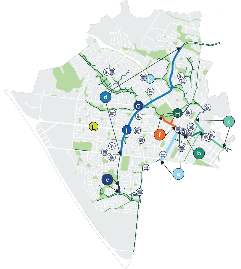
Prioritise projects
Using information like the walking and riding maps, Council
found gaps that we think should be fixed first. These will improve walking and riding which increases
transport choice, safety, and quality of life.
We are asking you to choose up to three projects for Council to prioritise in the short survey below the map. This gives us important information on which projects we should investigate first.
Click on each dot, then click on the image to see detailed information about the proposed priority.
Riding map
Riding is an important part of how residents can cover longer distances than walking but don't need a car. Residents told us in the Transport Strategy that they’d like to ride more, but find it too stressful.
The riding map shows the stress level of each riding route. The least stressful routes are low speed, low traffic, separated from traffic, or all of the above.
Tell us what you think. We used various sources of data and need to know if we’ve got it right, or if we have got it wrong.
The colours on the map indicate level of stress while riding:
- red = high stress
- orange = medium stress
- light green = low stress
- dark green = minimal stress
Walking map
Walking is the most basic way of travel, and an important part of how Hume residents get around. Residents told us in the Transport Strategy that they’d like to walk more, but find it too hard.
The walking map shows where we understand you can or can’t walk. It shows where
- streets have no footpaths
- footpaths only on one side
- footpaths go through open space
- where we are missing a crossing
- where the existing crossings are too stressful to be useful.
Tell us what you think. We used various sources of data and need to know if we’ve got it right, or if we have got it wrong. For example, have we shown a footpath through open space that doesn’t exist, or a street with no footpaths that actually has two?
For the crossings, we want to know what it is like to use it. Your lived experience allows us to make better decisions on what we prioritise and what we plan to deliver over the long term.


